
The Quiet Withdrawal — Photohike Mont Royal
- Lars-Henrik Roth

- Jun 7
- 8 min read
The Komoot route promised casemates, bastions, history buried in woodland. What followed was a morning between appearing and vanishing — skyglow above a sea of fog, a fortress the forest has been swallowing for centuries, and a white blanket that, in the end, took everything back.
Fortresses
A single word in a news headline caught my eye: Mont Royal. I'd used a nearby holiday park as base camp for Moselle adventures more times than I could count. Now it was a criminal trial — men who had bought a decommissioned military bunker cut into the hillside in 2012, and run a server farm for illegal operations out of it for years. Five floors of concrete, poured into the slope between 1979 and 1983, raided in 2019. And beneath that, deeper still in history: Louis XIV, the Sun King; his military architect Vauban; fifty hectares of fortifications built from 1687 — abandoned and razed only eleven years later.
Mont Royal has always swallowed its fortifications.
That was the thought I carried out into the dark at five in the morning. Two hours ahead of plan. I was on holiday, after all. The idea had been a short walk. But the forecast the night before had been clear: dew point spread under one degree, dead calm, fog signal in the Moselle valley. In my world, that means: GO. So five o'clock, light pack.

Resonant Names
I'd planned the Komoot route the evening before. The waypoints carried names like promises: East Bastion. Accessible Tunnel. Vaulted Cellar. West Bulwark. I pictured what awaited me — dark casemates, heavy walls, bastions still bracing themselves against the forest.
I'd driven past Mont Royal many times, looked up at the wooded slope from the holiday park below. That something lay inside that forest — I'd never doubted. I'd just never gone in.
The plan was simple: reach the Eulenwerk viewpoint first, wait for sunrise. If the ruins along the path showed any promise in the dark, I'd come back and walk the route again by daylight.
The beam of my headlamp bounced through the trees. On the phone screen, I watched the red waypoints approaching. I slowed. The beam moved across bark, moss, forest floor. A signpost. A few stones. I looked at the screen — the red dot was already behind me.
And so it continued. Point by point, falling behind me on the screen. No vaulted ceilings. No tunnel. No masonry holding its ground against the trees.
I stopped short. Into my nose crept that sharp, rank smell — close, unmistakable. Wild boar. The beam swept the treeline at the path's edge. Not a sound. An involuntary shiver. I moved on quickly.
Then just the forest again. Soundless. As if nothing had happened. The damp air had swallowed the smell.
When the last resonant name had fallen behind me, the decision was made. There was nothing here worth coming back for.
Then the forest opened.

The Landscape Begins to Breathe
The Eulenwerk viewpoint opened before me. The trees fell back, and there lay the eastern sightline — the Moselle valley near Enkirch, the lock, the last lights of night.
Silence. No wind.
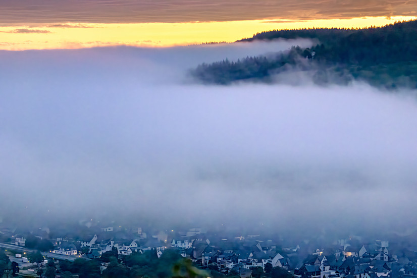
What I saw at first was not much: a narrow orange band above the ridge line, a first veil of mist low in the valley to the north. Harmless. I breathed out.
I knelt, pulled out the camera, checked the settings. The ISO auto had settled at 12,800. I swore, inwardly. No tripod, in this light — it was going to be a fight.
I looked up.
The fog had moved. Without a sound, while I'd been looking at the screen, it had crept closer — into the valley, toward me, as if it had been waiting for exactly that moment of inattention. And the clouds began to glow.


→Swipe to view more
From that harmless band on the horizon, movement grew.
Pink. Orange. Violet.
The dawn light didn't arrive as a single peak. It shifted from minute to minute. The fog rose, swallowing the houses, then the hills. The clouds burned. I photographed, knelt, stood again, shifted the frame. The ISO stayed high, the files were noisy — later I'd have to fight for every one of them.

Then the sun cleared the horizon. But it was already caught in fog.
The valley was gone. What half an hour before had been lights, houses, hillsides — now an even white surface, motionless, as if none of it had ever been there.


Fading I-III
I packed the camera and turned west.
In the Forest: Only Forest
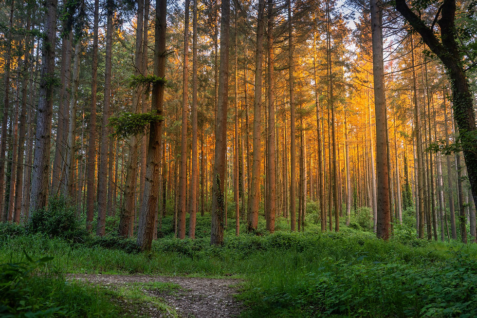
The morning light struck the trees from the side. The trunks glowed gold, the ground steamed faintly. It was beautiful here. I went deeper in.
Beneath my feet: strange ground swells, long ridges, depressions, the occasional pit cordoned off with barrier tape. Slowly, I began to read the topography. These weren't natural land forms. These were buried ramparts, collapsed casemates, the ground plan of something immense that was now invisible.
Then a sign. Large, at the path's edge, with a drawn reconstruction of the fortress — bastions, ditches, gates, walls, a system of fifty hectares. And on it, a dot: You are here.
I looked up. Tall trees, heavy with ivy. Ground swells. Silence.
In the forest: only forest.
Beautiful. Nearly romantic. But no trace of the fortress.
Further along, a rope park, silent in the early hour. Above the treetops, the first shreds of fog were drifting. Then, lower at the path's edge: a wall. With firing slits. I stopped for a moment.
One wall — that was all that remained visible of fifty hectares of fortification.
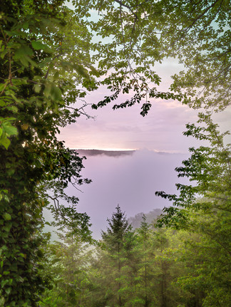
The forest opened to the west. The Kröv loop of the Moselle lay before me. Everything still sleeping. Silent houses, still water, the faint glow of streetlights. But the fog had rounded the bend — here too, it was pushing into the valley, slow, unhurried.
My autofocus found nothing to hold onto.
Beneath the White Blanket
I walked faster. The fog came to meet me.
Then everything turned milky. The Moselle loop sank. The hillsides sank. Finally, the sky itself sank.
Around me, only white — no horizon, no anchor point, no direction but the path beneath my feet.
Just before the first buildings of the holiday park, the blanket closed for good.
The morning had begun as a search for light. But the real image wasn't the appearing.
It was the vanishing.
Essence: The Seven-Image Series
Seven images from one morning: World, Fog, Island, Fire, Tipping, Forest Instead of Fortress, White.


Click to enlarge
Note: The images are optimized for web display and are shown here only in reduced resolution.
Service-Information
🌟 Highlights
Skyglow at the Eulenwerk — the strongest moment of this photohike: pink, orange, and violet above the rising fog sea. A rare event, and entirely dependent on the right weather window.
Fog sea over the Moselle valley — the eastern sightline, during temperature inversion, opens up sweeping views across Enkirch, the lock, the river, and the surrounding heights.
The view into the vanishing — what makes this hike powerful isn't any single panorama, but the moment when valley, houses, and hillsides slowly disappear beneath the white blanket.
Golden forest on the plateau — in the first light of morning, the woodland takes on a still, warm quality. Photographically, it carries most when fog or lingering haze adds a further layer.
The swallowed fortress — anyone expecting visible ruins will be disappointed. Anyone who understands that the forest itself has become the trace of the vanished fortification will find what the route is actually about.
📷 Photography Notes
Start very early. In mid-May, the critical light window falls just before and shortly after sunrise. The Eulenwerk viewpoint is walkable from the Landal Ferienpark Mont Royal; allow for darkness on the forest paths.
Treat fog not as a bonus but as the key condition. This route carries photographically when there is dawn colour, mist, haze, or low cloud. In clear skies and hard daylight, it loses its depth considerably.
Take the weather window seriously. A dew point spread under 1°C, dead calm, and a confirmed fog signal in the Moselle valley are strong indicators — but not guarantees. Conditions can shift within minutes.
Don't think only in panoramas. Once the valley disappears, the second part of the hike begins: tree gaps, fog veils, forest edges, backlight, and the slow dissolution of visibility.
Read the ground. The swells, depressions, and cordoned pits along the ruins path are not random terrain. They belong to the vanished fortress structure and change the way you see the forest.
Don't wait for classic ruin shots. Visible walls play only a minor role here, photographically. The strongest insight of the whole route is precisely that there is almost nothing to see.
💡 Particular Note
Mont Royal is not a reliable subject-hike for every time of day. On a sunny afternoon, the circuit offers little beyond a pleasant walk in the woods. The route comes into its own only when light and weather open a second layer: dawn colour above the Moselle valley, fog below the plateau, residual haze between the trees, or a white blanket slowly pulling the landscape back. Anyone planning this hike should ask not first about the route, but about the conditions.
🏆 Photohike Mont Royal — Rating
Category | Rating (1–10) | Comment |
Photo value | 8.1 | The morning as experienced was photographically strong: skyglow, fog sea, fading motifs, and woodland light add up to a coherent series. The route itself is highly weather-dependent. Without fog or dawn colour, the photo value drops sharply. |
Subject density | 7.0 | The range of subjects is narrow: the Eulenwerk, the fog view, the forest, a few traces of ruin, the western side. This tour lives not on many subjects but on a particular sequence — under the right conditions. |
Experience value | 8.4 | As a pre-dawn photohike, the circuit was intense: darkness, solitude, fog moving in, skyglow, and the quiet return through the forest. Under normal daytime conditions, the experience value would be notably lower. |
Accessibility / Safety | 8.3 | Well-maintained, officially waymarked forest paths, no technically demanding sections. An early start in darkness calls for attention, a headlamp, and a sure footing — but is entirely manageable. |
Overall impression | 7.9 | A strong but not universal photohike. Its quality comes from the interplay of history, fog, morning light, and the act of vanishing. Without those conditions, the route remains photographically restrained. |
🎒 Equipment & Photography
Camera: This photohike was unplanned and shot without a tripod. For similar conditions, a camera with good image stabilisation and reliable high-ISO performance is helpful.
Lenses: Wide angle for the Eulenwerk, fog panoramas, and sky; mid-range or light tele for fog layers, forest edges, and tighter compositions.
Tripod: Recommended when the hike is planned in advance. Without one, the early subjects are possible — but technically much closer to the edge.
Filters: Not necessary. The atmosphere comes from the light, fog, and cloud structure.
Post-processing: At high ISO values, careful noise reduction is worthwhile. The series holds for blog and Flickr; individual files should be reviewed at full resolution before large-format printing.
🔗 Discover More
Photohiking means: walking, seeing, telling. Learn more — and discover many more tours — on photohikers.de/en.
✉️ If this Photohike resonated with you or if you have a question about the tour, feel free to contact me directly by email or via the contact form.
➡️ All photohike image series can be found on Flickr.
© Lars-Henrik Roth / Wanderspezi – the Photohiker. Texts and images in this article are protected by copyright. Any use without prior permission is prohibited.


